Dijkstra to HeightMap Conversion
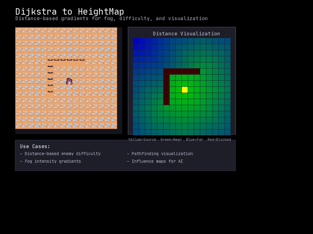
Convert pathfinding distance data into heightmaps for procedural generation, visualization, and gameplay mechanics.
Overview
A Dijkstra map stores the distance from every cell to a target point. Converting it to a HeightMap lets you use distance data for:
- Distance-based enemy difficulty scaling
- Fog/lighting intensity gradients
- Terrain generation based on paths
- Heat maps and influence visualization
Quick Start
import mcrfpy

scene = mcrfpy.Scene("quickstart")
mcrfpy.current_scene = scene

# Create a grid with walkable cells
grid = mcrfpy.Grid(grid_size=(20, 20))
for y in range(20):
    for x in range(20):
        grid.at((x, y)).walkable = True
scene.children.append(grid)

# Get dijkstra map from player position
dijkstra = grid.get_dijkstra_map((10, 10))

# Convert to heightmap
hmap = dijkstra.to_heightmap()

# Use the heights
player_distance = hmap[(5, 5)]  # Distance from (5,5) to (10,10)
API Reference
Getting a Dijkstra Map
# From a grid, compute distances from a source point
dijkstra = grid.get_dijkstra_map((source_x, source_y))

# Query individual distances
distance = dijkstra.distance((x, y))
Converting to HeightMap
# Basic conversion - the size of the map's window (the whole grid, unless the
# grid is over 1023 on a side or you passed radius=)
hmap = dijkstra.to_heightmap()

# A windowed map's heightmap starts at dijkstra.window[:2]; place it on a
# grid-sized HeightMap with copy_from
full = mcrfpy.HeightMap((grid_w, grid_h))
full.fill(-1.0)
full.copy_from(dijkstra.to_heightmap(), pos=dijkstra.window[:2])

# Custom unreachable value (default is -1.0)
hmap = dijkstra.to_heightmap(unreachable=0.0)
hmap = dijkstra.to_heightmap(unreachable=999.0)

# Custom output size
hmap = dijkstra.to_heightmap(size=(width, height))
HeightMap Access
# Get height at position
height = hmap[(x, y)]

# HeightMaps also support standard operations
# (see HeightMap documentation for full API)
Common Patterns
Distance-Based Enemy Difficulty
Spawn harder enemies farther from the player’s starting position:
def spawn_enemies(grid, player_start, enemy_count):
    """Spawn enemies with difficulty based on distance from start."""
    dijkstra = grid.get_dijkstra_map(player_start)
    hmap = dijkstra.to_heightmap(unreachable=0.0)

    enemies = []
    spawn_points = find_valid_spawns(grid)

    for point in spawn_points[:enemy_count]:
        distance = hmap[point]

        if distance < 5:
            enemy_type = "rat"      # Easy enemies near spawn
        elif distance < 10:
            enemy_type = "goblin"   # Medium difficulty
        elif distance < 15:
            enemy_type = "orc"      # Hard enemies
        else:
            enemy_type = "troll"    # Boss-tier far from spawn

        enemies.append(create_enemy(enemy_type, point))

    return enemies
Distance-Based Fog Intensity
Create fog that’s thicker farther from the player:
def update_fog(grid, fog_layer, player_pos):
    """Update fog intensity based on distance from player."""
    dijkstra = grid.get_dijkstra_map(player_pos)
    hmap = dijkstra.to_heightmap(unreachable=20.0)

    width, height = int(grid.grid_size[0]), int(grid.grid_size[1])

    for y in range(height):
        for x in range(width):
            distance = hmap[(x, y)]

            # Calculate fog alpha based on distance
            if distance <= 3:
                alpha = 0        # Clear near player
            elif distance <= 8:
                alpha = int((distance - 3) * 30)  # Gradual fade
            else:
                alpha = 200      # Dense fog far away

            fog_layer.set((x, y), mcrfpy.Color(20, 20, 40, alpha))
Visualizing Dijkstra as Color Gradient
Debug pathfinding by visualizing distances as colors:
def visualize_dijkstra(grid, color_layer, source):
    """Render dijkstra distances as a color gradient."""
    dijkstra = grid.get_dijkstra_map(source)
    hmap = dijkstra.to_heightmap(unreachable=-1.0)

    width, height = int(grid.grid_size[0]), int(grid.grid_size[1])

    # Find max distance for normalization
    max_dist = 0
    for y in range(height):
        for x in range(width):
            d = hmap[(x, y)]
            if d > max_dist and d != -1.0:
                max_dist = d

    # Color each cell
    for y in range(height):
        for x in range(width):
            dist = hmap[(x, y)]

            if dist == -1.0:
                # Unreachable - dark red
                color = mcrfpy.Color(60, 0, 0)
            elif dist == 0:
                # Source - bright yellow
                color = mcrfpy.Color(255, 255, 0)
            else:
                # Gradient from green (near) to blue (far)
                t = dist / max_dist
                r = 0
                g = int(255 * (1 - t))
                b = int(255 * t)
                color = mcrfpy.Color(r, g, b)

            color_layer.set((x, y), color)
River/Path Carving with Distance Fields
Use distance from multiple points to carve natural-looking paths:
def carve_river(grid, source, destination):
    """Carve a river-like path between two points."""
    # Get distance from destination
    dijkstra = grid.get_dijkstra_map(destination)
    hmap = dijkstra.to_heightmap(unreachable=999.0)

    # Start at source, follow decreasing distance
    current = source
    path = [current]

    while current != destination:
        x, y = current
        best_neighbor = None
        best_dist = hmap[current]

        # Check all neighbors
        for dx, dy in [(-1, 0), (1, 0), (0, -1), (0, 1)]:
            nx, ny = x + dx, y + dy
            if 0 <= nx < grid.grid_size[0] and 0 <= ny < grid.grid_size[1]:
                neighbor_dist = hmap[(nx, ny)]
                if neighbor_dist < best_dist:
                    best_dist = neighbor_dist
                    best_neighbor = (nx, ny)

        if best_neighbor is None:
            break  # No path found

        current = best_neighbor
        path.append(current)

        # Carve the path (make it water/floor)
        # NOTE: GridPoint.tilesprite is legacy - write to a TileLayer instead,
        # e.g. tile_layer.set(current, WATER_TILE)
        grid.at(current).tilesprite = WATER_TILE
        grid.at(current).walkable = True

    return path
Influence Map for AI
Create an influence map showing areas controlled by different factions:
def create_influence_map(grid, player_pos, enemy_positions):
    """Create influence map for AI decision-making."""
    width, height = int(grid.grid_size[0]), int(grid.grid_size[1])

    # Player influence
    player_dijkstra = grid.get_dijkstra_map(player_pos)
    player_hmap = player_dijkstra.to_heightmap(unreachable=100.0)

    # Combined enemy influence (take minimum distance to any enemy)
    # Compute each enemy's heightmap once, outside the per-cell loop
    # (recomputing it width*height times per enemy is wasteful).
    enemy_hmaps = []
    for enemy_pos in enemy_positions:
        enemy_dijkstra = grid.get_dijkstra_map(enemy_pos)
        enemy_hmaps.append(enemy_dijkstra.to_heightmap(unreachable=100.0))

    influence = {}

    for y in range(height):
        for x in range(width):
            player_dist = player_hmap[(x, y)]

            # Find closest enemy
            min_enemy_dist = 100.0
            for enemy_hmap in enemy_hmaps:
                enemy_dist = enemy_hmap[(x, y)]
                min_enemy_dist = min(min_enemy_dist, enemy_dist)

            # Influence: positive = player controlled, negative = enemy
            influence[(x, y)] = min_enemy_dist - player_dist

    return influence
Tip:
grid.get_dijkstra_map(root, roots=[...])also accepts multiple source points natively, which is the built-in way to get “distance to the closest enemy” instead of computing per-enemy maps and taking the minimum.
Performance Tips
- Cache dijkstra maps - Don’t recompute every frame if the grid hasn’t changed
- Use appropriate unreachable values - Choose values that make sense for your use case
- Consider size parameter - If you only need a portion, use custom size
- Batch operations - Convert once, query many times
Use Cases
| Use Case | Technique |
|---|---|
| Enemy difficulty scaling | Distance from spawn → enemy tier |
| Fog of war intensity | Distance from player → alpha value |
| Safe zone detection | Distance from hazards → safety score |
| Pathfinding visualization | Distance → color gradient |
| Terrain generation | Distance from features → elevation |
| AI influence maps | Compare distances from factions |
See Also
- Dijkstra Pathfinding - Basic dijkstra usage
- Fog of War - Visibility systems
- Dungeon Generator - Procedural generation